

Project 01 – Data Visualization
The theme I chose for the first project is boring place. Because I am a relatively autistic person, I don’t like to socialize, and I don’t like to go out. When I am bored, I like to lie on the bed, look at the window, and observe the world outside the window. I like to observe the changes and direction of clouds, and feel that they are free.

Mind-map
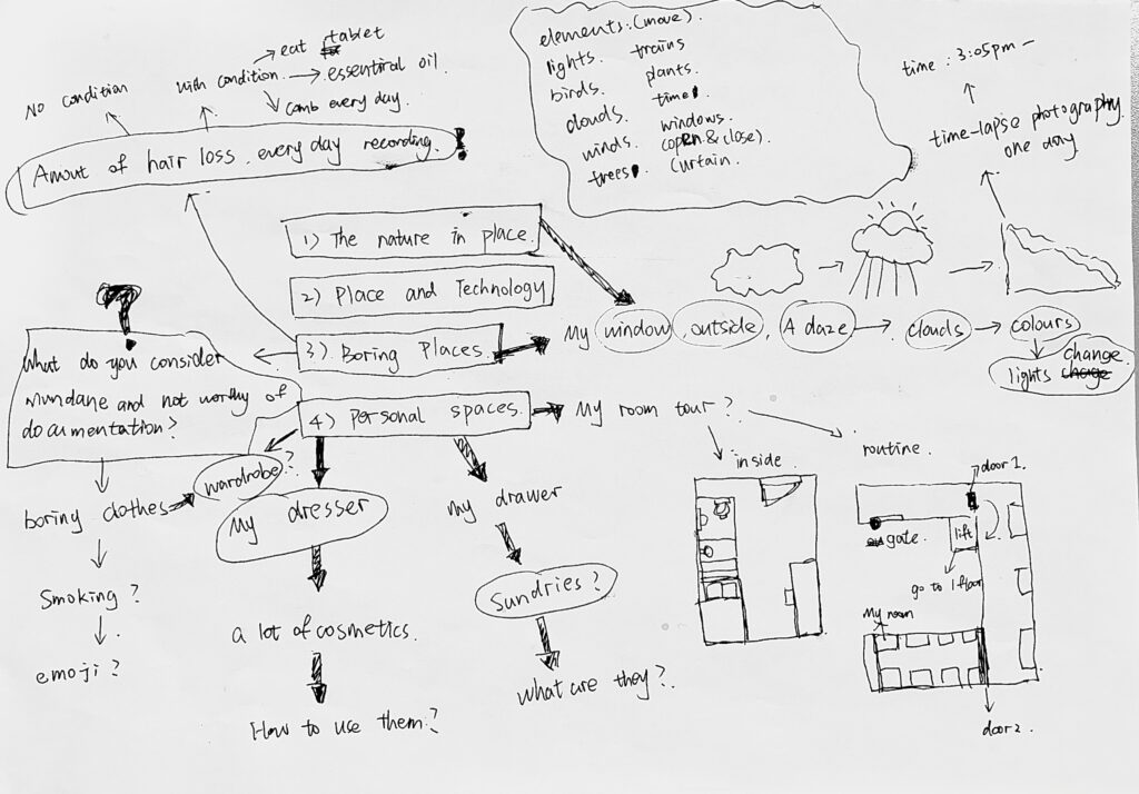
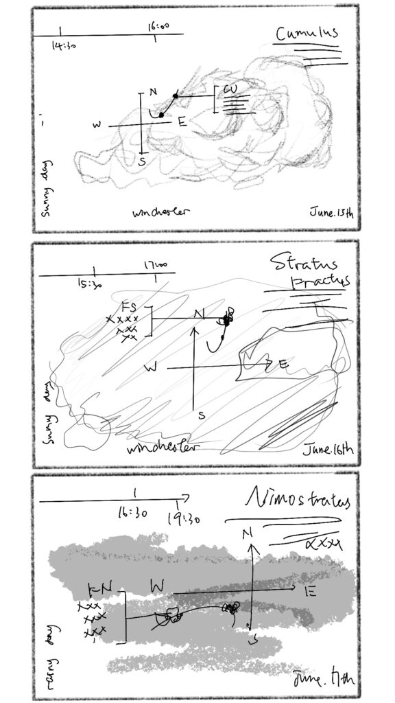
When recording the cloud, I was thinking about what data should I record in the cloud. Andy said in the class that the knowledge point of visualization is ASK (ask, story, knowledge), so I am going to record the wind direction of the day, the size of the cloud, and the different data generated by the change of cloud type over time.
Data collection
This is a blogger who caught a cloud while parachuting and returned to land. When I arrived on land, I couldn’t see anything in the bag, only air. After he took it home, he put the sealed bag in the refrigerator. After a period of time, something in the bag has frozen, and after it has melted, a part of water has formed. It can be seen that clouds actually have a certain weight, and at different temperatures, they will form different states, solid, liquid, and gas.
The weight of a cloud: the weight of a small cumulus cloud of one square meter or up to 200 tons
The weight of a cloud refers to the weight of the water droplets (or ice crystals) contained in the cloud.
The weight of the droplet varies with the type of cloud. Scientists have observed and determined that the water content of cumulus is 0.2-1 g per cubic meter; the water content of the aquifer or stratocumulus cloud of altocumulus is 0.1-0.5 g per cubic meter; the water content of two layers of cloud is per cubic meter 15 grams. If a cumulus cloud of 1 square meter looks like a relatively small cloud, it weighs 200 tons at an average content of 0.2 grams per cubic meter. This is not a small weight figure. Why can a small cloud of such a weight still float in the sky without falling to the ground? Because the diameter of the small water droplet in the cloud is 0.01 mm, its natural falling speed to the ground is also 0.5 cm per second, but due to the effect of the ground updraft, the cloud is suspended in the sky.
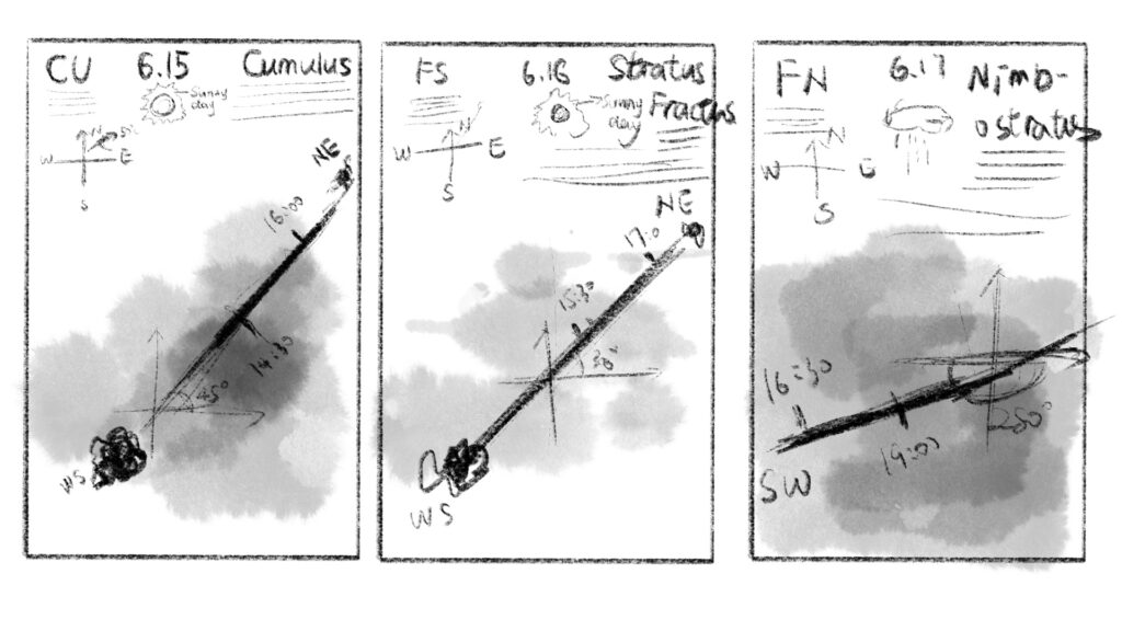
The above is the information I collected on June 15.
Cumulus (international abbreviation: Cu) is divided into three types: light cumulus, dense cumulus, and fragmentary cumulus. Cumulus clouds are well-defined, with convex tops, flat cloud bottoms, and mostly unconnected straight clouds between clouds; it is a cloud formed by condensation of water vapor or sublimation in winter due to the effect of low-level air convection. The bottom of the cumulus cloud is basically horizontal, the top is arc-shaped, and there are isolated, overlapping arcs or straight lines, and the appearance is similar to a cotton pile.
The height of the cumulus cloud base is generally 600-1200 meters in humid areas and 3000 meters in dry areas. The base of the cumulus cloud approaches the ground in the early morning and rises in the afternoon. Cumulus clouds generally appear in the morning, most in the afternoon, and gradually dissipate in the evening.「from Wikipedia」
The above is the information I collected on June 16.
stratus fractus (international abbreviation: Fs)are formed by the splitting of stratus clouds or the uplift of fog, and sometimes the uplift of light fog can also be formed, and it can also be directly formed in the mountains. stratus fractus is irregular loose fragments with variable shapes, which are gray or off-white fragmented clouds. Fragmental clouds rise slowly and often appear in the early morning after the rain. 「from Wikipedia」
The above is the information I collected on June 17.
Nimbostratus belongs to the low cloud family. The low, thick, and uniform precipitation clouds are dark gray. The horizontal distribution range is very wide, covering the entire sky, and the position of the sun and the moon cannot be seen. Nimbus clouds are formed by adiabatic cooling and condensation of warm and humid air due to the slow rise of cold air when large weather systems such as fronts invade. They are composed of water droplets or water droplets and ice crystals, and often produce continuous rain and snow. Even if there is no precipitation, there are often rain and snow flags drooping, making the cloud bottom very chaotic, and no obvious boundary can be seen. Under the nimbus cloud, there are often fast-moving, fragmented clouds, called Nimbostratus (Fn)「from Wikipedia」
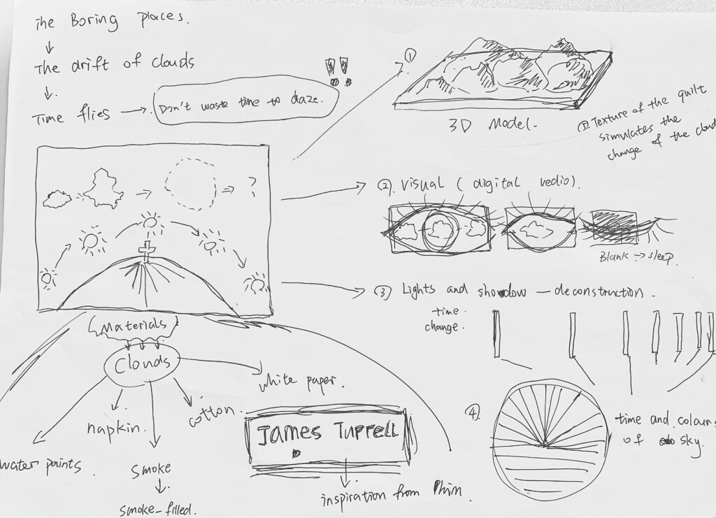
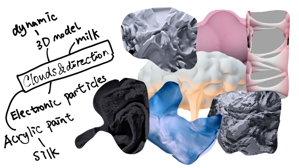
Sketch & Ideas
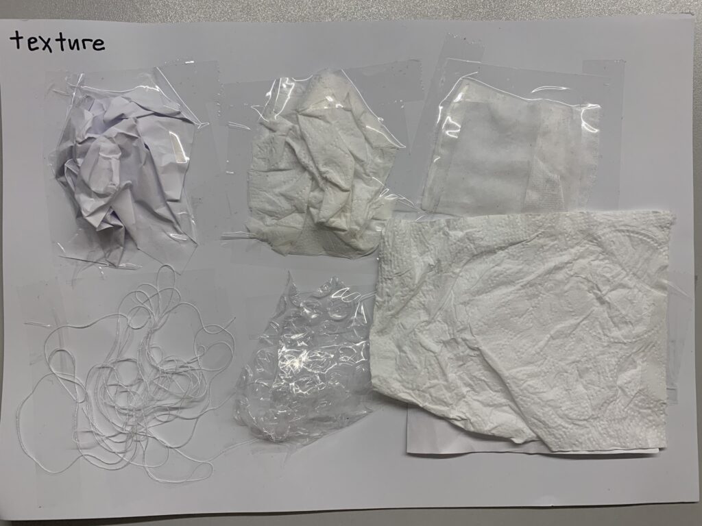
First of all, I first looked for materials with textures like clouds around me and made a sample. Because I am not yet sure how to express my visualization.

I made a collage and wanted to draw some inspiration from it. White clouds and directions remind me of scales, rulers, arrows, tie-dye, compass, gradient, and cells.
I will make three posters, the first series of the outcome. Maybe it can be made into a dynamic one. I don’t know whether my AE software level can achieve the effect. A dynamic poster or a static poster is tentatively decided. Probably the typography and idea are like this.
This is a three-shot. I will use Rhino software to make a model of the three-day data and display it dynamically. Display data with parabola + marking on the lens.
Outcomes
- Series 01
Since the exported gif format is too large, it cannot be uploaded on the website. If necessary, you can download it from here.👇 I saved them via One drive
- Series 02

